Vol.78, No.7 July 2016
Explanation of the cover photographs
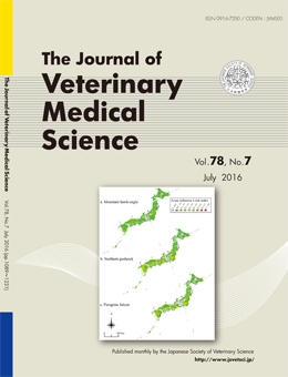
Spatial assessment of the potential risk of avian influenza A virus infection in three raptor species in Japan
Sachiko MORIGUCHI, et al. (pp.1107–1115)
Avian influenza A risk map for the mountain hawk-eagle Nisaetus nipalensis (a), northern goshawk Accipiter gentilis (b) and peregrine falcon Falco peregrinus (c). Avian influenza A risk indices were calculated using the equation: (avian influenza A risk index) × (habitat suitability index for each raptor). Black circles indicate sites at which the carcasses of each species infected with HPAI-H5N1 were collected from 2004–2011.
The avian influenza A risk map for the mountain hawk-eagle showed that most regions of Japan had a low risk for avian influenza A. In contrast, the maps for the northern goshawk and peregrine falcon showed that their high-risk areas were distributed on the plains along the Sea of Japan and Pacific coast. The infected peregrine falcons were also found at relatively high-risk areas.
This number is available on J-STAGE
https://www.jstage.jst.go.jp/browse/jvms/78/7/_contents